Now this is cool!
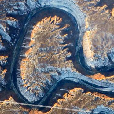
A An astronaut captured this photograph of Utah’s Green River doubling back on itself — a feature known as Bowknot Bend — from the International Space Station on Jan. 22, 2014. © NASA/REX/Shutterstock/Rex Images
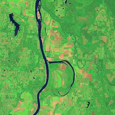
B On Aug. 4, 2014, the Operational Land Imager (OLI) on Landsat 8 acquired this image of the Arkansas River and the Holla Bend Wildlife Refuge. In the winter, it is common for the wildlife refuge to host 100,000 ducks and geese at once. NASA
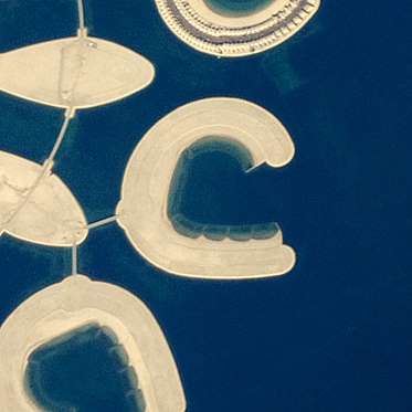
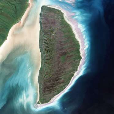
C An astronaut captured this photograph of an artificial island at Bahrain Island on Jan. 23, 2011. The beach sand on tropical islands is mostly made up of calcium carbonate from the shells and skeletons of marine organisms. NASA
D The Enhanced Thematic Mapper on Landsat 7 acquired this image of Akimiski Island in James Bay on Aug. 9, 2000. © NASA/REX/Shutterstock/Rex Images
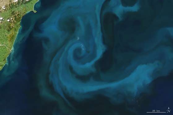
E On Oct. 25, 2009, the Moderate Resolution Imaging Spectroradiometer (MODIS) on NASA’s Aqua satellite captured this image of a phytoplankton bloom off the coast of New Zealand. © NASA/REX/Shutterstock/Rex Images
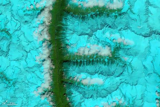
F The OLI on Landsat 8 acquired this false-color image of valleys and snow-covered mountain ranges in southeastern Tibet on Aug. 4, 2014. Firn is a granular type of snow often found on the surface of a glacier before it has been compressed into ice. © NASA/REX/Shutterstock/Rex Images
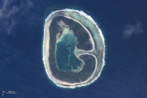
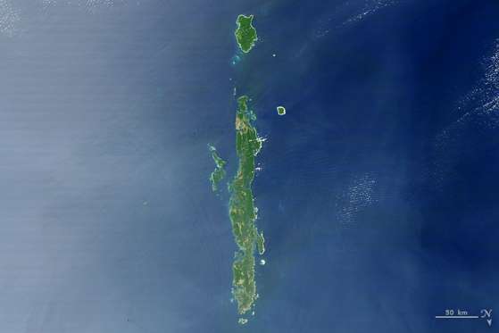
G This image of Pinaki Island was captured by astronauts on the International Space Station in April 2001. © NASA/REX/Shutterstock/Rex Images
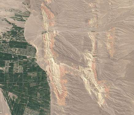
H On Aug. 30, 2014, the Operational Land Imager on Landsat 8 acquired this image of rivers running through colorful ridges in southwestern Kyrgyzstan. © NASA/REX/Shutterstock/Rex Images
I On Feb. 10, 2007, the MODIS on NASA’s Terra satellite captured this image of the Andaman Islands, India. The thin, bright rings surrounding several of the islands are coral reefs that were lifted up by a massive earthquake near Sumatra in 2004. © NASA/REX/Shutterstock/Rex Images
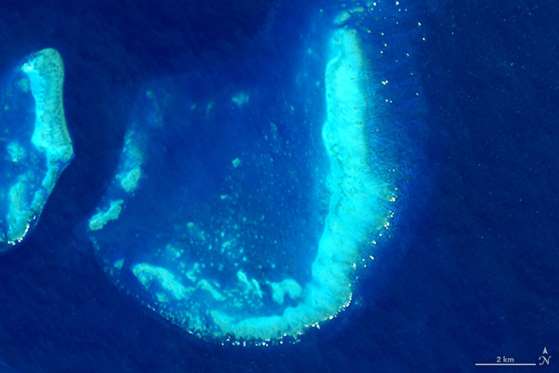
J On July 17, 2015, the Operational Land Imager on Landsat 8 captured this image of the Trunk Reef near Townsville, Australia. © NASA/REX/Shutterstock/Rex Images
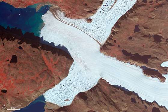
K On Aug. 3, 2015, the OLI on Landsat 8 acquired this image of glaciers at the Sirmilik National Park Pond Inlet in Mittimatalik, Canada. © NASA/REX/Shutterstock/Rex Images
L On Oct. 30, 2008, the MODIS on the Aqua satellite captured this image of snow across the northeastern U.S. © NASA/REX/Shutterstock/Rex Images
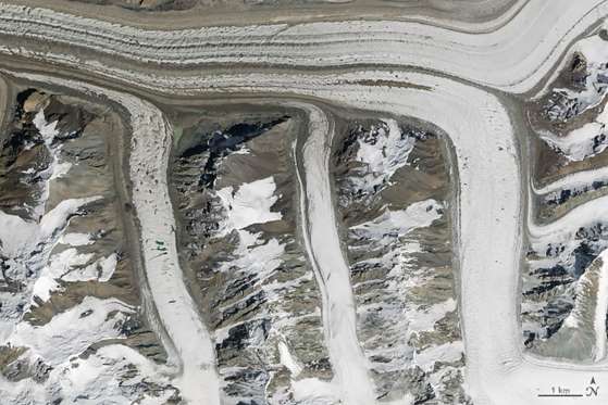
M On Aug. 14, 2015, the OLI on Landsat 8 captured this image of glaciers in the Tian Shan mountains in northeastern Kyrgyzstan. The trail of brown sediment in the middle of the uppermost glacier is a medial moraine, a term glaciologists use to describe sediment that accumulates in the middle of merging glaciers. © NASA/REX/Shutterstock/Rex Images
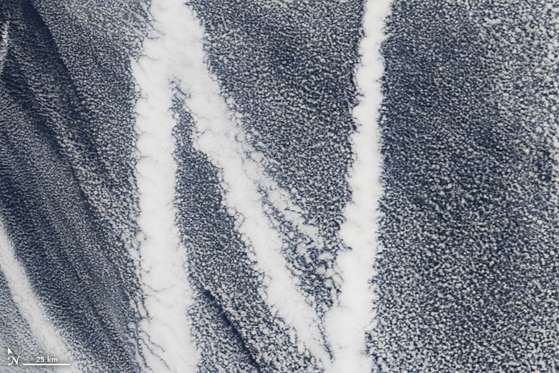
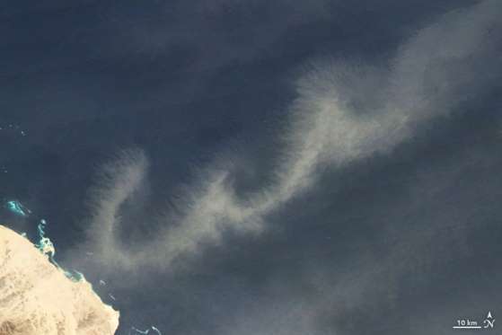
N On March 4, 2009, the MODIS on the Terra satellite captured this image of ship tracks over the Pacific. Ship emissions contain small particles that cause the clouds to form. © NASA/REX/Shutterstock/Rex Images
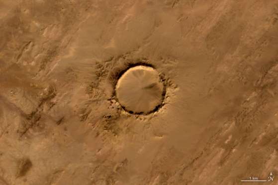
O On Jan. 24, 2008, the Advanced Spaceborne Thermal Emission and Reflection Radiometer (ASTER) on the Terra satellite captured this image of Tenoumer meteorite crater in Mauritania. The meteorite struck Earth between 10,000 and 30,000 years ago. © NASA/REX/Shutterstock/Rex Images
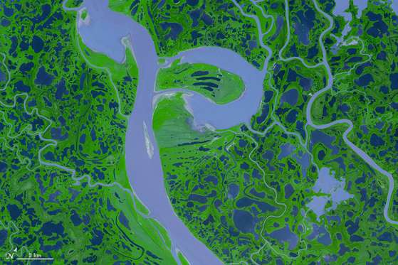
P On Aug. 4, 2005, the ASTER sensor on the Terra satellite captured this false-color image of the Mackenzie River Delta in Canada. © NASA/REX/Shutterstock/Rex Images
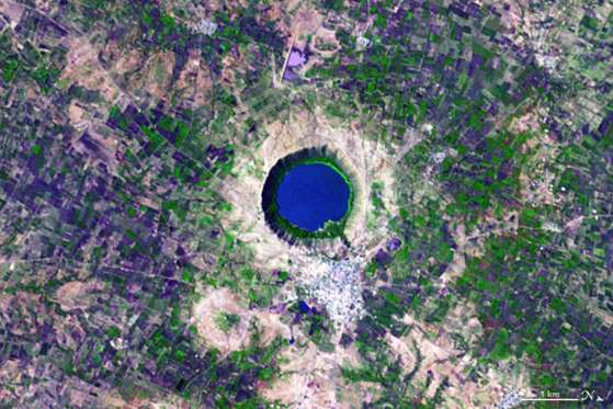
Q On Nov. 29, 2004, the ASTER on NASA’s Terra satellite acquired this image of Lonar Crater in India. Shocked quartz — minerals with an unusual structure that can only form under intense pressure — offers a clue that the lake was formed by a large meteorite. © NASA/REX/Shutterstock/Rex Images
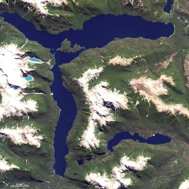
R On Jan. 20, 2015, the OLI on Landsat 8 captured this image of Lago Menendez in Argentina. © NASA/REX/Shutterstock/Rex Images
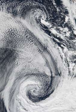
S On April 29, 2009, the MODIS on the Terra satellite acquired this image of clouds swirling over the Atlantic Ocean. © NASA/REX/Shutterstock/Rex Images
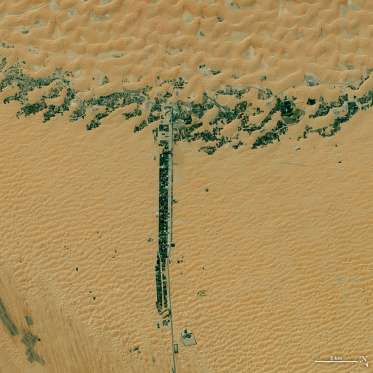
T On March 9, 2015, the OLI on Landsat 8 captured this image of development along two roads in the United Arab Emirates. © NASA/REX/Shutterstock/Rex Images
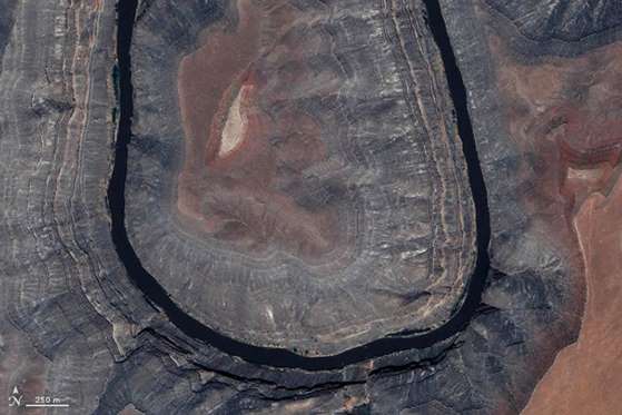
U On May 9, 2004, the Ikonos satellite captured this image of Gooseneck State Park in Utah. © NASA/REX/Shutterstock/Rex Images
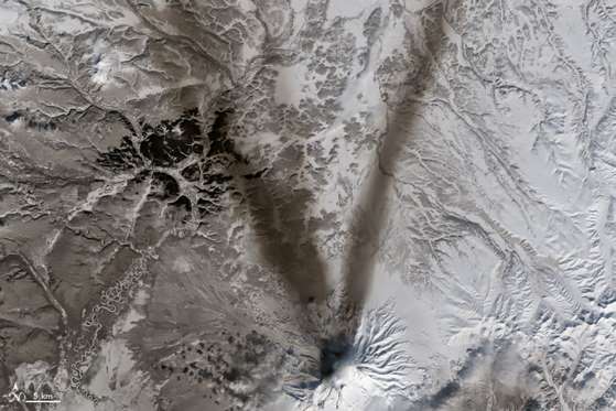
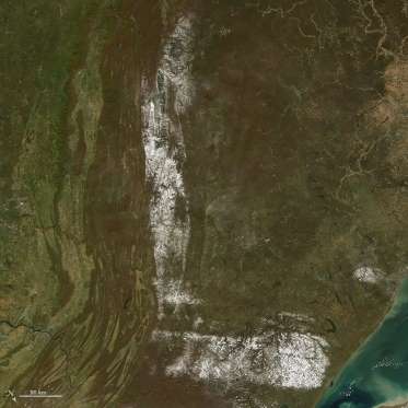
V On March 23, 2015, the OLI on Landsat 8 acquired this image of ash on the snow around Shiveluch — one of the largest and most active volcanoes on Russia’s Kamchatka Peninsula.
W On Jan. 13, 2009, the Moderate Resolution Imaging Spectroradiometer (MODIS) on NASA’s Terra satellite captured this image of dust blowing over the Red Sea. © NASA/REX/Shutterstock/Rex Images
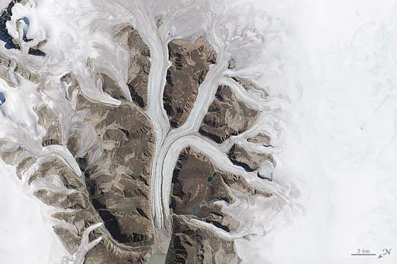
X On Aug. 7, 2012, the ASTER on NASA’s Terra satellite captured this false-color image of the northwest corner of Leidy Glacier in Greenland. © NASA/REX/Shutterstock/Rex Images
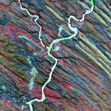
Y On Dec. 25, 2000, the Advanced Spaceborne Thermal Emission and Reflection Radiometer (ASTER) on NASA’s Terra satellite captured this false-color image of the Ugab River in Namibia. © NASA/REX/Shutterstock/Rex Images
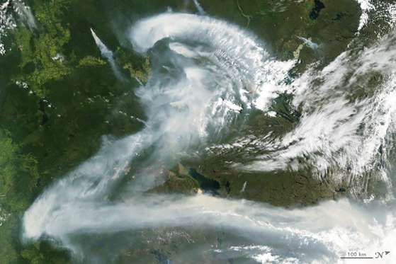
Z On July 11, 2012, the MODIS on NASA’s Aqua satellite captured this image of wildfire smoke over Canada. © NASA/REX/Shutterstock/Rex Images